BELISSIMA Expedition
The first scientific team to carry out research at the Princess Elisabeth Station, Frank Pattyn (ULB), Jean-Louis Tison (ULB) and a team of three international glaciologists travelled close to the Antarctic coast in the vicinity of Breid Bay in order to study the underside of the Antarctic Ice Sheet. The BELISSIMA (BELgian Ice Sheet-Shelf Ice Measurements in Antarctica) took place in November and December of 2008.
Glacier Anchor Points between the Continent and the Ocean
On the surface lies a vast expanse of ice with the occasional mountain peaks jutting out while down below sits the rocky continent covered by several kilometres of ice. The important question to ask is exactly how does the ice move?
As it moves off the continent and onto the ocean, the ice can become an ice shelf (ice that floats on the water yet remains attached to the ice sheet), at the end of which icebergs (blocks of ice floating on the water) calve off. As we know from Archimedes' Principle, the point at which the ice starts to touch the water is the point at which ice form the ice sheet starts to have an influence on sea level. As long as an ice shelf is present, it slows down the ice from the interior of the ice sheet as it flows towards the ocean. Yet the increase of the melt rate at the anchor point increases the rate at which the ice flows towards the ocean, something which ultimately contributes to sea level to rise.
The most interesting place to study the behaviour of the ice is the anchoring point, situated right at the point where the ice flows off the land and moves onto the water, becoming part of an ice shelf. Due to friction, the continental bedrock beneath the ice sheet slows the ice as it heads towards the ocean. However as sea level rises, water slips in between the ice sheet and the continental bedrock (which is heavier than the ice) via the anchoring point, which in effect inhibits the ability of the bedrock to slow the flow of the ice. Acting as a lubricant between the ice and the bedrock, this water increases the speed at which the ice sheet moves towards the sea and, and the extra weight increases the amount of force acting on ice shelves.
Objective and Methodology of the BELISSIMA Scientific Mission
The goal of BELISSIMA is to improve scientific understanding of anchoring points situated to the north of the Princess Elisabeth Station to see if the flow of the glaciers is accelerating with time.
The field study used three different methods:
- drilling in the vicinity of the anchor point
- taking transverse radar images of the anchor point
- tracking the movement of the ice using differential GPS
Unlike ice core drilling on the ice sheet, which allows you to see what the composition of the atmosphere was like in the past, drilling at an anchor point allows one to study the deformations the ice goes through as is flows over the anchoring point.
The radar profiles were used to examine the geometry of the ice sheet. Drawn along on a sledge, they send waves down to the bedrock which are immediately sent back to a receiver each time they detect a change in density. This change in density happens for example at the interface between the ice sheet and the bedrock or between different layers of ice. The density of the ice varies depending on how old it is and how much dust it contains. So it's possible to get a radar map of the ice sheet.
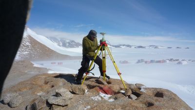
The last method aimed to measure the movement of the ice using two differential GPSs. The first GPS was stationary, fixed to a rock (nunatak), givng its position throughout the duration of the study. The second GPS was placed in the ice and was therefore mobile, giving its position as it moved. After getting an average value for the stationary GPS (there is always a margin of error that exists in taking this kind of reading), we examined the readings from the mobile GPS, taking the margin of error of the stationary GPS into account to correct any possible errors.
Future perspectives
The interest of such a study is ultimately to improve predictive mathematical models, taking into account the different parameters of the ice sheet. Don't forget that the loss of ice into the ocean contributes to sea level rise, so it's essential to understand ice dynamics and the formation of icebergs in order to better predict how sea level will rise in the next 100 or 200 years.
While the BELLISIMA mission is now over, the final results still need some time to be interpreted. A global research report will not be published for one or two years yet, the time needed for scientists, doctoral students and undergraduate students to analyse the samples we took back from Antarctica.
Picture: International Polar Foundation - © International Polar Foundation
