Just Back: An Interview with Detlef Damaske and Andreas Laufer
The following is an interview with geophysicist Detlef Damaske and geologist Andreas Laufer from the German Federal Institute of Geosciences and Natural Resources (BGR). Dr. Damaske has been working at the BGR for more than 30 years, and Dr Laufer is Head of the Polar Geology group at BGR.
Dr. Damaske spent several weeks at the PEA Station during the 2010-11 season, and Dr. Laufer is the research partner of Joachim Jacobs, the geologist who went to Utsteinen this year. The team was working on determining the geological history of the lithosphere (the Earth’s crust) in the Dronning Maud Land.
What were you doing in Antarctica during the 2010-11 season?
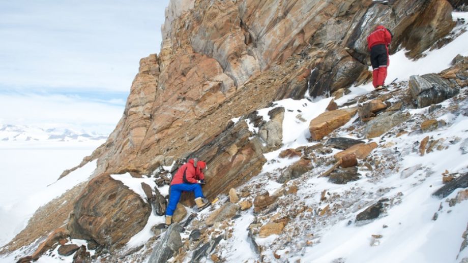
(Detlef Damaske) During the past season we had a small project with just one geologist and one geophysicist. The geologist was collecting rocks and taking structural readings. I’ve taken magnetic susceptibility readings, which gives us some idea about the magnetization of the rocks.
What does taking magnetic susceptibility readings of a rock tell you about it?
(Andreas Laufer) By looking at the magnetic signatures of a rock you can tell what kind of rock it might be. It’s interesting in Antarctica where there’s a lot of ice – 98% of the continent is covered in ice, with about 2% sticking out of the ice (we call these outcrops). So we don’t know what type of rock most of Antarctica is made of.
We geologists look at the rocks that stick out of the ice. What we’re interested in is the geological history of Antarctica, and in particular of the Dronning Maud Land with respect to how many continental fragments it’s made of, what the evolution has been over the past one billion years.
Detlef has been doing an aerogeophysical survey, which is complimentary to the work the geologists are doing. He can look through the ice and can tell what type of rock it might be underneath the ice – whether it might be granite, basalt, sedimentary rock, etc. This can give use an idea of what type of rocks lie underneath the ice.
(DD) To put this into context, we have another program going on: an airborne project that includes a magnetic survey of the rocks. It’s interesting to see whether we can already identify rocks or areas which have a high or low magnetic susceptibility so that we can interpret data on the rocks we are taking from an airplane. We need to do some ground-truthing so we can calibrate our instruments. Then we can extrapolate into the unknown areas underneath the ice about what kind of rocks might be there.
Why is the Dronning Maud Land so interesting geologically?
(AL) To answer that question, we have to go back 500-600 million years ago. Antarctica hasn’t always been an isolated continent at the South Pole. It was once part of greater landmasses which we call supercontinents. Antarctica has been part of two of these supercontinents, one of which we call Gondwana. Gondwana was formed between about 500-600 million years ago and then began to break apart about 180 million years ago. It contained all the landmasses currently located at least in part in the Southern Hemisphere – Africa, Australia, New Zealand and South America – along with the Indian Subcontinent.
This supercontinent formed 600-500 million years ago through the collision of what was once the western part of Gondwana and the eastern part of Gondwana. The boundary between these two landmasses that collided must be somewhere in Dronning Maud Land, but we don’t know exactly where. There’s one point further to the west in the Shackleton Range where we know there are remnants of oceanic crust that have exactly the right age. So from there into the Dronning Maud Land there must lie the suture zone where the western and eastern parts of Gondwana collided and fused. The collision formed very high mountain ranges similar in scale to the Himalayas of today, and the remnants of this mountain range are all preserved today in Dronning Maud Land. So it’s very interesting for a geologist to look at Dronning Maud Land with respect to the processes that take place during the formation, dispersal, and erosion of mountains.
Also, if you look at the part of Antarctica where the German Neumayer Stations and the South African SANAE IV Station are located close to the coast in Dronning Maud Land, this part of Antarctica was at one time part of Africa. This is what was left of the Kalahari craton (an old and stable part of the Earth’s crust that have survived the movement of the tectonic plates) in Africa. Land here was once part of what is now southern Africa before Gondwana formed but remained on the Antarctic side after Gondwana broke part. It’s one of the ways we know the Gondwana continent existed.
What methods do you use to date the rocks you find?
(AL) We use a method we call geochronology. We sample the rocks, take them back to the laboratory, and then crush them to extract certain kinds of minerals and date them using radiometric dating techniques (which use known radioactive decay timescales from one element or isotope into another to determine the age of rocks) such as the uranium-lead method, or potassium-argon method, argon-argon method, and so on.
These methods use a laser called a SHRIMP. It’s the best method we have today for dating these types of rocks – mostly on zircon. It’s a very high-precision method of dating because you can use this tiny crystal only a few microns across, and you can use the laser to date the centre of the crystal or the rim of the crystal. So you can get a history of several steps of geological evolution in one crystal. This method can go back billions of years to the time when the Earth formed 4.5 billion years ago.
Did you fulfill your research objectives this season? If not what is left to do for next year?
(DD) We completed about 95% of what we could have done during this relatively short season. The remaining research we need to do requires a different logistical approach, which brings us to the 2011-12 season. During this past season, se got around on skidoos. But next season we’ll need to extend our area of research not only in distance but also in elevation, so we’ll need to find other methods; otherwise we could lose days climbing up mountains to take samples.
We’ll use the results we get from the research we did this year – which we hope to get by the summer – to help us focus on specific areas to do research. We have an idea of where we want to go, but we still need to select the best places to target.
(AL) What we know now are basically field results. We have some structural geological data about how the rocks folded, faults that cut trough the rocks and the movement along these faults. But we know nothing about the age of the faults. Regarding the suture zone for Gondwana I mentioned earlier, we need to know whether the faults we found do date from the time that Gondwana formed. If they are older, then it’s the whole story that’s already known about Antarctica re-discovered using other methods.
What’s important is that as soon as the samples get back to Germany, there are some high-priority samples that need to go directly to the lab for geochronology dating. We hope to have some data on the age of the rocks sometime between June and August – well before the next season in Antarctica so we can better select the areas we want to go to. That’s the main objective for next season.
Will you publish any results before the start of the next season?
(AL) We might talk about our results at conferences. It’s too early to approach any highly-ranked journals. Before we do that we need more data. There are a number of conferences where we can present our findings. There’s at least one very important conference this year called the International Symposium on Antarctic Earth Sciences. It takes places every four years, and it will be in Edinburgh, Scotland this time. We plan to give a presentation there. We won’t have the high-precision data before then, but we can talk about our research. After next season we’ll start thinking about publishing our results.
What was daily life in Antarctica like living at the PEA Station and working in the field?
(DD) We worked out of the PEA Station the entire time. On other expeditions to Antarctica we’d also had field camps in addition to working at a station, but this time we were based at the station and went out into the field every day. We took a one or two hour skidoo ride out to the furthest locations we surveyed and then returned in the evening to the station in the evening, which was a luxury in a way because normally when you’re operating out of a field camp you don’t have that.
We had a really good time at the station and got all the support we needed. Everything we needed to help us do our research was provided. It helped quite a bit because you could concentrate on your research and daily logistics. I’m really looking forward to the next season.
How was it living in a station that has an energy management system?
(DD) You have to get used to it. It was ok as long as you paid attention to which outlet your computer was plugged into. After a while you learn which outlet often gets more power. If there was a large group of people using power then you had to adapt, but recently this has been improved from what I hear. Overall the energy management system was good, adequate for what everyone needed and very clean.
Picture: The BGR team in the field - © International Polar Foundation - René Robert