Nighat Amin: Taking Snow Measurements for Scientists
Nighat "Gigi" Amin details the International Polar Foundation’s participation in GLACIOCLIM-SAMBA, an Antarctic project coordinated by the Laboratoire de Glaciologie et Géophysique de l'Environnement (LGGE) in Grenoble, France.
The Antarctic component of the GLACIOCLIM project is monitoring what is known as the “surface mass balance” of Antarctica. Could you please explain what this is and why it's important?
The Antarctic Ice Sheet is the largest mass of ice on the planet. If it were to loose a significant amount due to warming, it would contribute significantly to sea level rise. Scientists are trying to better understand the processes contributing to the accumulation and loss of ice from the Antarctic Ice Sheet.
Through snowfall, ice is added to the ice sheet. But ice is lost through several processes:
- Sublimation: Part of the ice is transformed into water vapour by the sun
- Melting: Ice melts and then either evaporates or flows into the ocean
- Abrasion: The wind removes ice from the ice sheet
By combining these various factors, scientists are able to calculate what is called the surface mass balance of the Antarctic Ice Sheet. Based on this, they can estimate by how much the Antarctic Ice Sheet is likely to contribute to sea level rise.
What are the various techniques used to monitor the ice sheet's surface mass balance?
There are several observation techniques. From satellites measuring changes in elevation, to aircraft taking radar measurements, to ground based observations aimed at measuring the rates of loss or accumulation in different regions of the Antarctic. A lot of people are involved in this international effort to collect data and assess whether the surface mass balance trends are a cause for alarm.
Why was the International Polar Foundation chosen to take part in the GLACIOCLIM project?
In East Antarctica, a vast, unoccupied and little studied area, the ground truth data, as it is sometimes referred to, is hard to come by. The Princess Elisabeth Station is in the middle of a zone where few datasets exist, and there is no general agreement on the actual rates of ice mass loss or gain.
By contrast, the West Antarctic Ice Sheet and the Antarctic Peninsula host the largest number of stations and thus these parts of Antarctica have been extensively studied by some of the best equipped teams of researchers in Antarctica.
Data from NASA's twin GRACE (Gravity Recovery and Climate Experiment ) satellites, launched in 2002, have been yielding data that is intended to shed light on the overall surface mass balance for the Antarctic Ice Sheet. But early data is not in exact concordance with existing surface mass balance estimations. There is a very real need for ground truth observations to help determine the actual trends in this region.
For the last four years, the International Polar Foundation has been involved in monitoring a glacier stream going from the Sør Rondane Mountains to the Princess Ragnhild Coast. The IPF team uses similar methods as scientists use on Alpine or Andean glaciers. We also work in accordance to an observation protocol supplied by the LGGE.
What work did you have to do this year? Could you explain the various methods you used to collect data?
This season, Alain Hubert, Erik Verhagen and I (Nighat "Gigi" Amin) took measurements from 3-6 February. We concentrated on measuring snow accumulation and snow density. Measurements were taken along a 180 km transect from the coast to the vicinity of the Vesthaugen Nunatak. This transect is 300m away from the Crown Bay route, which is used by the cargo traverses. Data were collected during the last traverse, on the way back to Princess Elisabeth.
Approaching the coast, where the precipitation rate is higher, rates of accumulation are monitored using 4 meter long accumulation stakes made of transparent polycarbonate. By measuring the orientation, height and length of the stakes, we can also gather information on wind speed and wind direction. Accumulation rates over this past year have been very high. In some areas, stakes were buried under heavy snow drifts.
Being transparent and covered in snow, the stakes were notoriously difficult to find. Thankfully, using precise GPS coordinates, Alain could locate them even in blizzard conditions. We placed new stakes upwind from the Crown Bay route to prevent the convoys from having any influence on the accumulation around them.
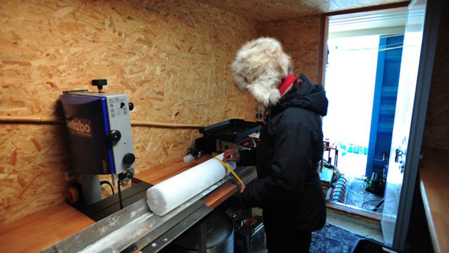
That's accumulation, what about snow density?
We also had to evaluate snow density by taking ice cores in accumulation areas. The cores were taken to a depth of 2.5m, every 6 to 9km along the 180km transect I mentioned. Unfortunately, activity had to be interrupted due to equipment failures. We still need to drill four snow cores. We hope to do this as soon as the weather and schedule permit.
Combined, snow accumulation data and density profiles help to identify areas where accumulation is taking place, where ablation is occurring or where the snow is turning into ice next to blue ice fields.
Like last year, collected data will be sent to the Glacioclim SAMBA team, and will be made available to modellers, who will use them to model local changes in snow and ice mass, energy balance, glacier flow, and large scale climate changes.
You mentioned other possible contributions from the International Polar Foundation in the future...
We can also get incoming solar radiation data from the Automatic weather Station next to Princess Elisabeth Station. As this area is relatively protected from the prevailing winds in the region, we would like to install more automatic weather stations in the coming years to collect data on local wind and radiation conditions in areas closer to the glacier.
The area around the Romnoes Nunatak would be particularly interesting to monitor. It has a large blue ice ablation zone, caused by catabatic winds accelerating over the mountain.
Other possible contributions to the surface mass balance estimation effort could come in the future from the GPS and gravimetry instruments installed at Princess Elisabeth by the Royal Observatory in Uccle, which measure continental uplift and analyse the relation between ice mass variation and crust deformation.
Modelling the ice streams is also possible using GPS transmitters positioned on several points along the ice stream. These transmitters can then be monitored by satellite to establish rates and direction of flow. These data can then be used to determine mass displacements in three dimensions.
What are the perspectives for scientific research at Princess Elisabeth?
There is great potential for research opportunities at Princess Elisabeth due to its isolated location. International interest in doing research here continues to grow. We have ten nationalities at the station this year and more scientists than support crew, which is probably a record of sorts.
Picture: Measuring and weighting a core to determine snow density - © International Polar Foundation