Successful Mass2Ant Fieldwork at the Lokeryggen Ice Rise
The Antarctic Ice Sheet is contributing approximately 0.5 mm of sea level rise per year. The timing and magnitude of the Antarctic Ice Sheet’s contribution is difficult to assess, partly due to the variability of its surface mass balance and its future evolution. Surface mass balance is the net addition or removal of mass at the surface of the ice sheet.
The BELSPO- funded Mass2Ant research project aims to better understand the processes controlling the surface mass balance in East Antarctica, its variability over the last three centuries and, ultimately, improve model projections of surface mass balance changes of the East Antarctic Ice Sheet.
This 2021-2022 fieldwork season is the fourth and last one of the Mass2Ant project. This year the work was accomplished in three weeks at the remote location of Lokeryggen Ice Rise, which is located near the coast, about 160 km from the Princess Elisabeth Antarctica (PEA) station.
On the geophysics side, Scientists collected a 26 km-long ground-penetrating radar transect going from east to west over the Lokeryggen Ice Rise to examine the variations in the surface mass balance from grounding line to grounding line, extending the data previously collected in 2017.
The crew also collected a high resolution 200 x 200 m radar data grid over the center of the Ice Rise to compare the surface mass balance recorded by the 200 m deep ice core collected in 2017 with this radar-derived record.
To constrain the ice dynamics of the Lokeryggen Ice Rise, 21 pRES measurements (phase-sensitive radio echo sounding, aka phase-sensitive radar data) were collected over a distance of 10 km across the ice crest, where a glaciological phenomenon known as a Raymond Bump is suspected to be present. Raymond Bumps occur at ice divides due to the slower vertical compaction of the ice which shows up as big arches in the ice layers.
To measure ice properties, two types of measurements were combined at five locations on the Ice Rise: drilling shallow firn cores and acquiring laser scans of the surface. These locations were spread out on the east and west sides of the Ice Rise to sample sites with different snow accumulation and erosion conditions.
The firn cores will provide information on the chemical composition of the ice between these locations and their varying atmospheric conditions, as well as on the density and age of the snow/ice layers. The age of the snow layers allows to date the radar profiles, and the densities of the snow layers can be combined with the laser scan.
The snow surface is scanned by laser to provide a detailed map of surface roughness (how smooth or irregular the surface is) at each location over a radial area of 120 m. The surface roughness influences the signal that is received by satellites, but so does snow density. It was thus important for the scientists to get both the surface laser scan together with the firn core measurement to distinguish the impact of these two parameters on the satellite signal. The team revisited the same five locations after storms to measure changes in surface conditions due to strong winds and snowfall.
Indeed, the team experienced three storms over the three weeks of fieldwork. The weather was generally characterized by low visibility, lots of snowfalls and quite strong winds, sometimes making data collection a real challenge. Despite the difficulty of the weather conditions the team is proud to announce that this season was a great success as they managed to accomplish all the foreseen objectives. The scientists are now looking forward to further analyse the data they have collected.
The MASS2ANT team would like to thank the whole IPF team who helped make this once again a successful campaign and for their warm welcome at PEA!
- Maaike, Sarah, Frank and Marie
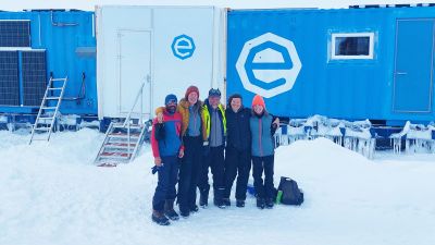
Picture: Mass2Ant project team in the field - © International Polar Foundation
